NAPPY SOLDIER / PUBLIC DATA CONTROL ROOM
GOD’S EYE VIEW.
Initializing public-data globe…
OCEAN / DATED SURFACE-CURRENT ESTIMATES · SHIPS / AIS NOT CONNECTED · GLOBAL HOTSPOTS / FIRMS NOT CONNECTED · SUBMARINES / NO PUBLIC LIVE FEED
EARTH OBSERVATION / SAME AREA, TWO DATES
BEFORE / AFTER.
Choose the same location and two observation dates. Clouds and missing coverage may obscure the ground; images do not measure elevation change.
NASA GIBS / Worldview · Dated satellite observations, not a live video feed
Marine traffic needs AISStream; global FIRMS fire detections need a NASA MAP_KEY. Submerged submarine positions are not available as a public live layer. Ocean arrows are coarse surface-current estimates in m/s, with glyph lengths scaled for visibility. NASA fire map ↗ · NOAA ocean viewer ↗
FEED COVERAGE & RECORDING NOTES
Layers run together and update independently. Aircraft are public ADS-B observations: civilian coverage is a 250-nautical-mile region around the view; military coverage includes only publicly broadcasting aircraft received by the provider. Coverage and updates vary. This page does not control aircraft.
USGS earthquake reports may be revised. NOAA global infrared is delayed satellite imagery; radar covers the contiguous United States. Satellite positions are orbital predictions. Check each layer’s source time and status before describing a recording as live. Cockpit POV is a simulated 3D view using public position/altitude/heading data; it is not an onboard camera. Select an aircraft on the globe before using Selected Aircraft, or choose Civilian/Military Cockpit to enter an available contact. Next cycles contacts; Exit returns to the globe.
Public traffic cameras use the upstream camera catalog, frame proxy and bounded HLS relay. Availability differs by city; camera snapshots are labeled separately from live video. Source status in the camera panel identifies fallback imagery. X posts are loaded only when you submit a public post link; embeds retain their original author and controls. This page does not automatically collect or verify eyewitness posts.
Built with Bilawal Sidhu’s open-source God’s Eye View (MIT), Cesium and the displayed map providers. Their credits stay visible in recordings. Optional Google photorealistic buildings, voice and vessel tracking require provider setup. Press Escape to leave browser full screen.
// WELCOME TO THE UNDERGROUND
NAPPY
SOLDIER+
NEUROFUNK. HEAVY GUITARS.
NO RULES OF ENGAGEMENT.
Drum & bass meets live metal guitar.
Independent sound. Cinematic worlds. Full force.
DRUM & BASS+NEUROFUNK+LIVE GUITAR+NU METAL+JUNGLIST CULTURE
360° / MISSION BRIEFINGS
MEET THE SOLDIERS.
Sista Soldier
VOICE MUTED01 / OPERATION PLAYBACKS
LATEST TRANSMISSIONS.
LATEST TRANSMISSION
LATEST TRANSMISSION
LATEST TRANSMISSION
LATEST TRANSMISSION
LATEST TRANSMISSION
LATEST TRANSMISSION
YOUTUBE / NAPPY SOLDIER
PLAYLIST FREQUENCY.
Swipe the videos or drag the slider. Play right here.
Radio returns when the video stops.
02 / GLOBAL FREQUENCY
GOD’S EYE VIEW.
Global frequency provided by God’s Eye View.
GOD’S EYE VIEW / EARTHQUAKE PREVIEWM3.5–8.8

Loading recent earthquake reports.
USGS · Past 24 hours · Updates automatically
WHAT YOU CAN EXPLORE
- EarthquakesExplore recent seismic activity around the world.
- Live street camerasLook into available public camera feeds.
- WeatherExplore weather maps and satellite overlays.
- Military aerial trafficFollow publicly broadcasting aircraft.
- Civilian street trafficCheck road conditions through public traffic cameras.
- Civilian planesExplore flight activity across the map.
- Live cockpit viewFollow tracking data from a simulated aircraft cockpit.
- Voice commandsNavigate with supported voice command tools.
03 / DECLASSIFIED HARDWARE
INSIDE THE MACHINE.
Scroll to separate the base, tank or guitar. Scroll back to rebuild it. Drag to inspect, or use the manual assembly controls.
SCROLL TO SEPARATE /
LAS VEGAS / 36.1699° N · 115.1398° W
BGR AUDIO / LAS VEGAS
Live guitar tracking, drum & bass production, mixing and cinematic experiments.
// 01 / AUDIO ARSENAL
HEAVY FREQUENCIES.
Neurofunk drum & bass, nu metal guitar and junglist energy. Stream the records or head straight to the download catalog.
 NS / BASS GRIME RECORDS
NAPPY SOLDIER / OFFICIAL STREAMS
TURN IT UP.
TAKE IT WITH YOU.
Explore the independent catalog, from raw guitar-driven neurofunk to cinematic drum & bass.
CATALOG SELECTION
IN THE ARSENAL.
Elite Loop
Drum & Bass · Nothing But · 2026
I Got a Brand New Bag, of Ganja
Nappy Soldier & Bangkok Badman · Drum & Bass
They Hate
Drum & Bass · LW Recordings
Out of Ammo
NuMetal Drum & Bass Neurofunk Mix
Nappy Neurofunk Soldier
Drum & Bass Neurofunk Mix
Dark & Nappy
Drum & Bass Neurofunk Mix
ON ROTATION
SPACE P*SSY / EP.
// 02 / VIDEO ARCHIVE
OPERATION PLAYBACKS.
47 selected transmissions. Studio sessions, live shows, guitar covers, remixes and cinematic music videos.
47 TRANSMISSIONS
AI music videos
AI music videos
AI music videos
Music videos
Remixes
Remixes
Remixes
Remixes
Remixes
Remixes
Remixes
Remixes
Remixes
Remixes
Remixes
Remixes
Remixes
Remixes
Remixes
Remixes
Remixes
Remixes
Remixes
Remixes
Remixes
Remixes
Remixes
Remixes
Remixes
Remixes
Music videos
Music videos
Studio sessions
Studio sessions
Studio sessions
Studio sessions
Music videos
Covers
Covers
Covers
Covers
Covers
Live shows
Remixes
Music videos
Music videos
Music videos
No transmissions found. Try another search or category.
// 03 / ARTIST INTEL
THE OPERATOR.
Nappy Soldier / Mark Anthony / Marcadelik. Independent sound. Human musicianship. New frontiers.
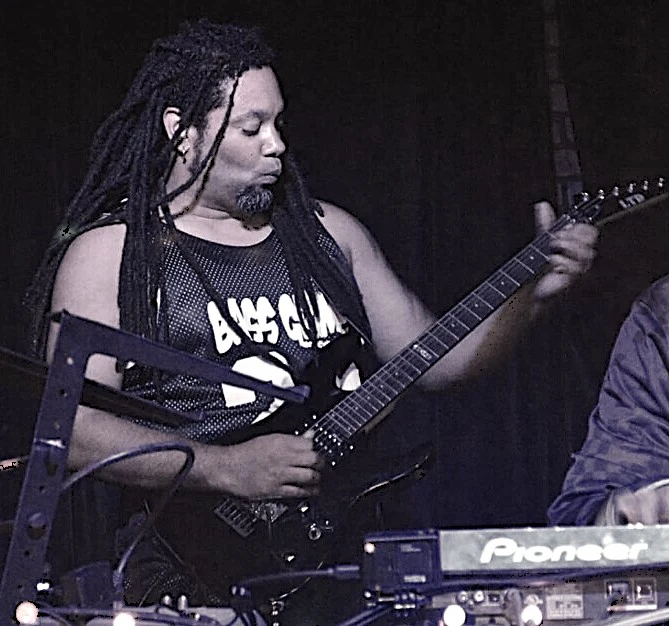
GUITARIST · PRODUCER · RECORDING ENGINEER
BUILT IN THE STUDIO.
UNLEASHED ON STAGE.
Nappy Soldier brings live heavy guitar into neurofunk drum & bass, combining the weight of nu metal, the pulse of jungle and the detail of studio production.
Mark Anthony’s recording career began in 1993, with engineering study and work in a 2-inch tape studio at Revolt Records. Bass Grime Records followed in 2013, creating an independent home for bass music.
Today, he runs BGR Audio in Las Vegas. Live guitar, FL Studio arrangement, mixing and mastering shape the records. His current visual work expands that sound into cinematic worlds and AI-assisted music videos.
The live-band archive also features MC Mickey Flair and DJ Sean Stylee. Explore the sessions and performances to hear how the project has evolved.
1993RECORDING ROOTS
2013BASS GRIME RECORDS
6 / 7 / 8STRINGS IN THE STUDIO
360° / THE OPERATOR
NAPPY SOLDIER + XIPHOS.
OPERATOR INSPECTION
NAPPY SOLDIER
FULL ROTATION.
Inspect the artist and guitar from every side. Drag across the footage, move the angle control, or play the complete turn.
Video turntable · angles approximate · drag or use the keyboard slider.
PUBLIC CHANNELS
DIRECT FROM THE SOURCE.
For new releases and recent posts, follow the official artist channels.
// 04 / VISUAL INTELLIGENCE
FIELD OF VIEW.
On stage. At the desk. Inside the cinematic universe. Real performance photography alongside clearly labeled cinematic artwork.
// 05 / THE SUPPLY DEPOT
SOUND. GEAR. IDENTITY.
Official music downloads and the next wave of Nappy Soldier merch.
01 / DIGITAL ARMORY
LOAD YOUR CRATES.
Official releases and DJ downloads from the Nappy Soldier Beatport catalog.
SHOP MUSIC ON BEATPORT02 / FIELD EQUIPMENT
NSNAPPY SOLDIERBASS GRIME RECORDS
THE NEXT MERCH DROP.
Get the first word when official gear is ready. No products are on sale here yet.
GET MERCH DROP ALERTS ↗// 06 / DIRECT COMMS
JOIN THE FREQUENCY.
Get release alerts, fresh videos, show announcements and merch drops directly from Nappy Soldier.

UNDERGROUND / DIRECT
YOUR LINE TO
THE FRONT.
RECRUITMENT CHANNEL
STAY IN THE LOOP.
Choose a direct connection to the music.
See our privacy information. Your address is used only for the updates you request.
// 07 / BOOKING & CONTACT
CALL IN THE HEAVY SIGNAL.
Live drum & bass with guitar, studio collaborations and creative projects. Tell us what you have in mind.
// 08 / INTERACTIVE ARMORY
INSIDE THE MACHINE.
Rotate, inspect and pull the assembly apart. Nine machines. Rotate, inspect and separate the Robo Dino, Battle Drone, unmanned UC 3000, studio equipment and Xiphos.
BUNKER / ASSEMBLY STUDYDRAG TO ROTATE · HOVER TO SEPARATE
Reference-based metal assembly studies. Drag to rotate, hover to separate, or use the slider. Supplied product photographs are available for comparison.
// 09 / PRIVACY
YOUR SIGNAL. YOUR CHOICE.
Privacy and media information for the Nappy Soldier website.
Email updates
When you request updates, your email address and confirmation status are used to manage your subscription. Confirm using the link sent to your inbox. Each confirmation or mailing includes an unsubscribe link. Contact nappysoldier@gmail.com for removal or questions.
Booking inquiries
The details you supply are used to respond to your inquiry. They are not added to the mailing list.
External media
Bundled video thumbnails are served by this site. YouTube videos and Spotify players load when you choose to play them. Those services process their own usage data and may use cookies. You can use the direct platform links instead. Submitting a public X post URL loads X’s official widget and that post. The separate God’s Eye View page connects to named public-data and imagery providers; those providers may log requests.
Local preferences
The site remembers your sound preference in this browser. Music can be stopped at any time. Sound does not start until you choose it.
Preview forms
On the preview site, forms prepare an email draft in your email application. The request is sent only when you send that email. The installed WordPress theme supports on-site booking inquiries and confirmed email registrations.
Cinematic interface
The home-page artist globe and operation videos are cinematic presentation. The separate God’s Eye View page retrieves public earthquake, weather, aircraft and satellite data from the named providers; those providers receive network requests and may log usage. Data is delayed, incomplete or unavailable at times. Cinematic artwork is labeled separately from performance photography.